
Amid experts’ warning that there could be more tsunamis on the Sunda Strait in the wake of Saturday’s tragedy, Indonesia’s Meteorology, Climatology and Geophysics Agency (BMKG) says it has installed a tsunami warning system for the surrounding coastal areas.
During a press conference on Tuesday evening, BMKG head Rahmat Triyono said the agency has installed three earthquake sensors on the southern coast of Sumatra and three more near the western coast of Java — both of which lie on either side of the volcano Anak Krakatoa.
“If at least three [sensors detect tectonic activity] we can know where the quake originated from. If not from Krakatoa, then the area would be safe [from a similar tsunami], but if it came from Krakatoa, then we would take anticipative measures,” Rahmat said, as quoted by Detik.
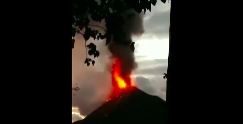
BMKG said there has been ongoing minor tectonic activity on Anak Krakatoa since it triggered the Dec. 22 tsunami.
“If we can detect tremors of at least 3.4 in magnitude, then BMKG may issue a [tsunami] warning,” Rahmat said.
Following the tsunami, much has been made about the lack of a functioning tsunami detection system on the Sunda Strait — and, indeed, across Indonesia — since 2012 due to buoy sensors being vandalized or stolen.
However, even if a tsunami buoy was functioning on the Sunda Strait before the tsunami, authorities may not have been able to predict the tsunami based on small tectonic activity alone. But now, with their analysis of Saturday’s tsunami, BMKG believes that even minor volcanic and/or tectonic activity on Anak Krakatoa could cause a landslide on the volcano, which would in turn potentially trigger another tsunami.
At any rate, the agency has advised residents of coastal areas around the Sunda Strait to keep a distance of at least 1 kilometer from coastlines due to ongoing heavy rain and strong winds, which have created waves measuring up to two meters high.
The most recent death toll from the Sunda Strait tsunami stands at 429, with 1,485 people injured and another 154 still missing, while thousands of displaced survivors are still crammed in shelters and hospitals.
The tsunami was Indonesia’s third major natural disaster in six months, following a series of powerful earthquakes on the island of Lombok in July and August and a quake-tsunami in September that killed about 2,200 people in Palu on Sulawesi island, with thousands more missing and presumed dead from those double disasters.
Meanwhile, thousands were expected to pray for loved ones at mass graves and mosques today to mark the 14th anniversary of the 2004 Boxing Day tsunami.
It was one of the deadliest disasters in history, killing some 220,000 people in countries around the Indian Ocean, including some 168,000 Indonesians, most in Aceh at the northern tip of Sumatra.
Indonesia, a vast Southeast Asian archipelago, is one of the most disaster-hit nations on Earth due to its position straddling the so-called Pacific Ring of Fire, where tectonic plates collide.
With additional reporting by AFP

