
A 6.4-magnitude earthquake struck near the Aceh province mainland today, according to the Meteorology, Climatology and Geophysics Agency (BMKG), though, thankfully, no tsunami warning was issued.
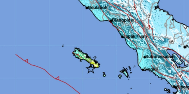
The earthquake struck at 1:05pm, 24 kilometers southwest of Sinabang city on Simeulue island — which itself is located southwest of the Aceh mainland — at a depth of 13 kilometers. BMKG reported that the earthquake was felt as far as in the North Sumatra capital of Medan.
#Gempa Mag:6.4, 07/01/2020 13:05:18 (Pusat gempa di Laut 24 km BaratDaya SINABANG), Kedlmn:13 Km Dirasakan (MMI) III Tapak Tuan, III Singkil, III Gunung Sitoli, III Nias Utara, II – III Medan, II Nias Barat, II Meulaboh, IV Simeuleu, #BMKG
— BMKG (@infoBMKG) January 7, 2020
There have been no reports of casualties as of the time of writing, though some buildings in Simeulue have been reported to have sustained minor damages such as cracks on walls.
Indonesia experiences frequent seismic and volcanic activity due to its position on the Pacific “Ring of Fire,” where tectonic plates collide.
In 2018, a 7.5-magnitude quake and a subsequent tsunami in Palu on Sulawesi island killed more than 2,200 people, with another thousand declared missing.
On December 26, 2004, a devastating 9.1-magnitude earthquake struck off the coast of Sumatra and triggered a tsunami that killed 220,000 across the Indian Ocean region, including around 170,000 in Indonesia.

