
Indonesia’s Meteorology, Climatology, and Geophysics Agency (BMKG) has issued a warning of aftershocks and potential tsunami following a 6.1-magnitude earthquake that hit the Maluku islands.
An alert shared on the agency’s official Twitter account specifically warned those living along the coastlines of Japutih and Apiahu on Seram Island, one of the biggest islands in Maluku province.
“Beware of aftershocks and a potential tsunami due to underwater landslides … Immediately stay away from coastlines and head to higher grounds,” the tweet, posted at 1:17pm, reads.
BMKG : WASPADA Gempa Susulan dan Potensi TSUNAMI akibat longsor ke/di bawah laut bagi Masyarakat di sepanjang Pantai Japutih sampai Pantai Apiahu Kabupaten Maluku Tengah, P. Seram, Maluku.
SEGERA menjauhi pantai menuju tempat tinggi
BMKG terus memonitor gempa susulan. https://t.co/hdFVw8ep5D
— BMKG (@infoBMKG) June 16, 2021
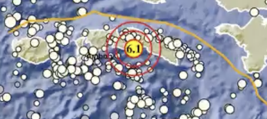
The 6.1-magnitude quake occurred at 11:43am Western Indonesia Time (WIB) at a depth of 10 kilometers, approximately 67 kilometers southeast of Central Maluku. BMKG’s initial alert following the earthquake stated that there was no tsunami potential.
The National Disaster Management Agency (BNPB) said in a statement issued this afternoon that there have been no reports of fatal casualties thus far, as local residents sought higher grounds for safety.
Several clips showed sea level dropping at a port on Seram Island, though there have been no major updates since.
BMKG Maluku mengeluarkan peringatan tsunami di sepanjang Pantai Yaputih sampai Pantai Apiahu, Kabupaten Maluku Tengah, Pulau Seram, Maluku.
Peringatan itu dikeluarkan setelah gempa 6,1 SR terjadi, Rabu (16/6/2021) sekitar pukul 13.43 WIT.
pic.twitter.com/TJbslkWYp3— Tj 🇮🇩NKRI (@cahyowib) June 16, 2021
At the time of publication, BMKG has yet to lift the tsunami warning.
Read more news and updates from eastern Indonesia here.

