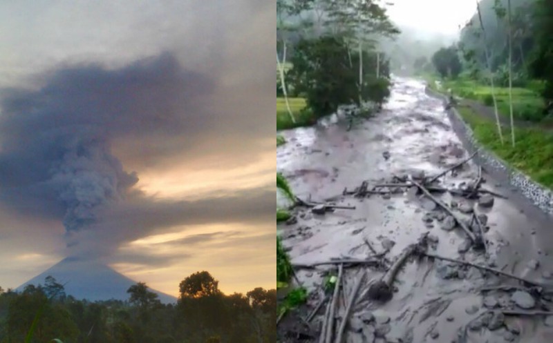

Residents around Bali’s Mount Agung have been warned to stay away from river channels surrounding the smoking volcano as small lahars—destructive mud flows or so-called cold lava flows—have started down the slopes of the mountain.
The Yeh Sah River in Rendang district, Karangasem for instance is usually pretty dry, but as of Monday morning, brown mud was observed flowing down the slopes of Mount Agung. The river smelled of sulfur and the lahar, or flow has been sweeping other debris in its path like rocks, tree trunks and soil, along with it, while agricultural land in the area has already reportedly been damaged by the mud.
Guys, stay away drom disaster prone areas of Agung Mount.It is rainy season in Bali so it will increase cold lava due to heavy rains and keep far away from rivers. #disasterawareness #agungmount #bali #stayaware pic.twitter.com/asnEtvzV6F
— BNPB Indonesia (@BNPB_Indonesia) November 27, 2017
“The ash released by Mount Agung was hit by rainwater and has now become mud in the Yeh Sah River,” Karangasem Police Supt. I Wayan Gede Ardana told Detik on Monday.
While the flows don’t seem too deadly at this time, the Volcanology and Geological Disaster Mitigation Center (PVMBG) says rain will only intensify the lahars around Agung—a big deal since Bali is now entering the rainy season.
“This is a small lahar, where eruption materials are carried by rainwater to the river,” PVMBG head, Gede Suantika said on Monday.
“You could say it’s lahar because there is a smell of sulfur,” said head Rendang Village Mount Agung Post monitor, I Dewa Mertayasa.
According to Mertayasa, PVMBG will investigate further to determine the level of volcanic material content in the flows.
“We have taken samples to first be checked in the laboratory so we can know the level of volcanic material content,” he said.
PVMBG is appealing to local residents to stay away from the river flows, which have mainly been observed on the southern slopes of the volcano, coming upstream of Sebudi Village.
Though additional reports from Bali Post show that Ban, a village on the northern slopes of Agung has also been experiencing flows.

People caught in lahars can drown or be buried, cautions a video produced by VolFlim, a partnership of volcanologists and filmmakers, profiling the volcanic phenomenon. Lahars can move rapidly and occur immediately after an eruption or even weeks or years after and can sweep away structures like bridges and houses.
Lahar Impacts#Agung #Bali https://t.co/4WRxOgJAGx
— Dr Janine Krippner (@janinekrippner) November 27, 2017
“I ask that residents be aware of the lahars along the river coming from Mount Agung. Although the pyroclastic volume of Mount Agung’s eruption has not been much,” National Disaster Mitigation Agency (BNPB) spokesman Sutopo Purwo Nugroho said in a statement.
Waspadai banjir lahar hujan (lahar dingin) di sekitar Gunung Agung. Banjir lahar hujan sudah terjadi di beberapa tempat di lereng Gunung Agung. Hujan akan meningkat. Jangan melakukan aktivitas di sekitar sungai. Radius 8-10 km harus kosong dari aktivitas masyarakat. #Bali pic.twitter.com/5vuZ4KTTYa
— Sutopo Purwo Nugroho (@Sutopo_BNPB) November 27, 2017
As of Monday morning, the exclusion zone around Mount Agung has been extended to a radius of eight to 10 kilometers from the volcano’s crater, as the alert status for a larger eruption was raised to the highest level.
Local residents have been asked to evacuate the exclusion zone but do so in a calm and orderly fashion.
Meanwhile, the airport has been shutdown for at least 24 hours.
The volcano is located in Karangasem, far from the island’s tourist hub of Kuta (approximately 75 kilometers) and those outside the exclusion zone are urged to remain calm and “not to panic.”

