
Got a tip? Send it to us at manila@coconuts.co.
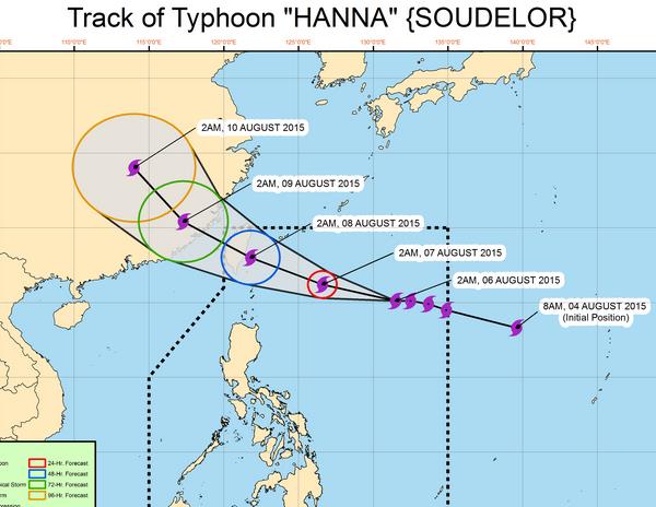
Super Typhoon Hanna (international name: Soudelor) is forecast to leave the Philippine area of responsibility by Sat morning, Aug 8, weather bureau PAGASA announced.
WEATHER DISTURBANCE
Senior weather specialist Christopher Perez said Hanna entered PAR at around 7am on Wed, Aug 5, and is expected to enhance the southwest monsoon (habagat).
As of 5am on Thu, Aug 6, the typhoon is located 955 kilometers (km) east of Basco, Batanes. The typhoon is currently packing 175 kilometers per hour (kph) winds and gusts of up to 210 kph.
Perez said the western sections of the Visayas and Mindanao areas, including Palawan, will be affected by heavy rain. Meanwhile, isolated thunderstorms will hit Metro Manila.
The weather bureau predicts the typhoon will be out of the Philippine area of responsibility by Saturday morning, Aug 8, and will go to Taiwan.
POWERFUL STORM
Soudelor developed into the world’s most powerful storm of the year on Tue, Aug 4, as it took aim at Japan, Taiwan and China after trashing the Northern Marianas.
The storm was roaring across the western Pacific Ocean packing wind gusts up to 220 miles per hour (354 kph) according to the Joint Typhoon Warning Center which rated it a maximum category five.
It was stronger than Cyclone Pam, the previous strongest storm of 2015, which killed at least 15 people when it slammed into Vanuatu, also in the Pacific, five months ago.
No deaths have been attributed to Soudelor, but it left a trail of destruction across the Northern Marianas where acting governor Ralph Torres declared a “state of major disaster and significant emergency” after it struck late Sunday.
Nearly 400 people were packed in emergency shelters after Soudelor ripped roofs off houses and left residents without power, water and wastewater services.
“I’ve seen multiple primary power poles down; I’ve seen cars flipped over the road; I’ve seen lots of torn roofs,” John Hirsh, executive director of the American Red Cross in Saipan, told Pacific Daily News.
Damage was “extensive” across the island and there had been significant damage to public infrastructure, he said.
Many roads were impassable in Saipan — the Northern Marianas main island, the seat of government and hub of the local economy — while in the harbor at least three vessels were ripped from their moorings.
In Hagatna, on neighboring Guam, the weather service warned boats to stay away from exposed reefs and beaches because of “hazardous surf” and “life threatening” rip currents.
It said Soudelor would continue to intensify as it swept across open water for the next 24 hours before starting to weaken.
It was expected to be down to category four or three by the time it hit southern Japan, Taiwan and China from late Thursday.
Tropical typhoons and cyclones typically form in the western Pacific between May and October with Pam the most destructive so far this year.
In addition to the fatalities in Vanuatu, about 75,000 people needed emergency shelter after their homes were destroyed and almost all food crops were wiped out.
Typhoon Maysak slammed into the Federated States of Micronesia in late March killing at least four people and leaving more than 5,000 in need of food, shelter and other emergency assistance. —with Agence France-Presse (AFP)
Photo: PAGASA
This article has been re-published with permission from ABS-CBNnews.com.

