
A T3 warning has been issued and, well, it could get rougher.
Two storms are headed toward Hong Kong, with the first — a tropical storm — likely to skirt south of the city today and the second — classed a super typhoon — possibly headed straight for us this weekend.
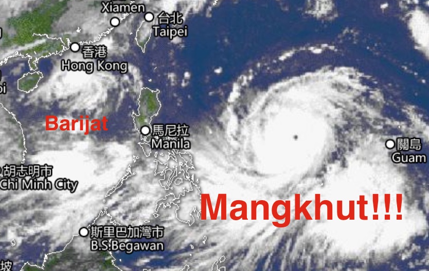
Let’s deal, initially, with the first: Barijat.
The Observatory at 12:20pm issued a T3 warning — aka Strong Wind Signal, No.3 between 11am and 1pm — as the tropical storm edges closer to the city.
“This means that winds with mean speeds of 41 to 62 kilometres per hour are expected,” the weather service warned.
“Make sure objects likely to be blown away are securely fastened or taken indoors. Stay away from the shoreline and not to engage in water sports.”
The storm, which developed from a low pressure system to the east a few days ago, expected to pass between 100 to 200 kilometers south of Hong Kong this afternoon, bringing strong winds and occasional squally showers.
Now, meet super typhoon Mangkhut, currently moving across the Western Pacific between Guam and the Philippines.
With winds currently around 240km at its center, Mangkhut’s expected to intensify as it continues tracking west.
According to the Observatory, there’s a one in two chance the territory will take a direct hit from Mangkhut, RTHK reported.
Speaking to the public broadcaster, senior scientific officer Yeung Kwok-chung indicated that things would get rough.
“The associated heavy rain squalls and storm surge will pose a threat to the region. According to the present forecast track, there is a chance that Mangkhut will come very close to Hong Kong”, Yeung said.
Turning to weather conditions during the week, things are going to be windy and stormy today and tomorrow, with sunny periods returning on Friday and Saturday before conditions “deteriorate significantly” with the arrival of Mangkhut on Sunday.
Here’s the Observatory’s advice for a T3 warning:
- Please take precautions now. Make sure objects likely to be blown away are securely fastened or taken indoors.
- Drains should be cleared of leaves and rubbish. People in low-lying areas should take precautions against flooding.
- Seas are rough and there are swells, you are advised to stay away from the shoreline and not to engage in water sports.
- Avoid staying in areas exposed to high winds. Drivers using highways and flyovers should be alert to violent gusts.
- Construction and property management practitioners should make sure that overhanging facilities and temporary structures outdoors are securely fastened or placed on the ground, and complete precautionary measures as soon as possible.
- Small vessel owners should now complete all safety arrangements and return to nearby typhoon shelters.
- Small vessels not yet in typhoon shelters should seek shelter without delay. Use heavy anchors and check that all deck fittings are firmly fastened.
- Listen to radio, watch TV or browse the Hong Kong Observatory’s website and mobile app for the latest information on the tropical cyclone.


Reader Interactions