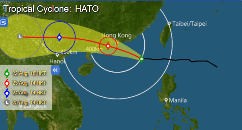
In terms of the weather, Hong Kong summers are defined by three things: heat, humidity, and typhoons. Luckily/unluckily for us, we’re about to experience the full trifecta as Typhoon Hato (or “Sky Pigeon” as it’s more amusingly named in Chinese) approaches the city amid a record-breaking heatwave.
The Hong Kong Observatory (HKO) recorded a maximum temperature of 36.6 degrees across the SAR at 2pm today, making it the hottest day of the year and breaking a 132-year record. The temperature reached a scorching 39 degrees at the Wetland Park in Tin Shui Wai, while a high of 38 degrees was recorded in Sham Shui Po.
According to the HKO, a continental airstream is affecting Hong Kong under the influence of Typhoon Hato, bringing very hot weather and moderate winds. The light winds have hindered the dispersion of air pollutants, leading to a higher-than-average level of pollution today.
As of 5pm, an Air Quality Health Index (AQHI) at 8 or above (indicating a “Very High” health risk) was recorded at general and roadside stations in Tsuen Wan, Kwai Chung, Tuen Mun, Tung Chung, Causeway Bay, and Central.
The literal hot streak is set to end tomorrow as Typhoon Hato is expected to bring rainy, squally weather to the SAR for the rest of the week.

At 6pm, the typhoon was estimated to be about 410 kilometers east-southeast of Hong Kong, and is forecast to move west-northwest at about 25 kilometers per hour towards the coast of Guangdong. Tropical Cyclone Strong Wing Signal No. 3 was issued at 6:20pm, while gusts reaching 90 kilometers an hour or above may continue to affect Hong Kong.
Unless Hato moves away from its current track or weakens, the HKO will consider issuing the No. 8 Gale or Storm Signal at around midnight. At the moment, there is a 30 to 40 percent chance that the storm will hit Hong Kong directly tomorrow.
Hundreds of Cathay Pacific and Cathay Dragon flights scheduled for tomorrow have been canceled as a result of the weather, a spokesperson for the airlines told the SCMP.


