

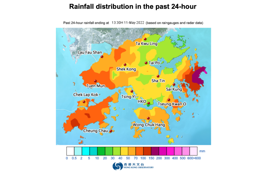
A thunderstorm warning is in place today in Hong Kong as heavy rains hit the city, with more than 70 millimeters of rainfall recorded in Sai Kung.
The Hong Kong Observatory issued the warning at 11pm on Tuesday, and it was still in force on Wednesday morning through to this afternoon.
“Showers and thunderstorms associated with an active trough of low pressure will continue to affect Hong Kong today,” said the observatory on its website.
It added that members of the public should take note of the latest weather information it issues.
More than 20 millimeters of rainfall were recorded over many places in the morning, with rainfall even exceeding 70 millimeters over Sai Kung. More than 50 millimeters of rainfall were recorded over the western part of the New Territories.
The observatory forecast the weather to be cloudy with showers and squally thunderstorms on Wednesday.
Showers will be heavy at times at first, with moderate southeasterly winds becoming south to southwesterlies, it added.
While Macau and several mainland cities, including Guangzhou, suspended classes for Wednesday, students in Hong Kong continued to go to school for lessons.
Macau also issued a red rainstorm warning on Wednesday.
Some Hong Kong netizens slammed the forecaster for not suspending classes in order to protect students.
“It will be troublesome when students’ classes end and the heavy showers hit,” said one internet user.
“It’s usually the elderly picking up the [younger pupils]. It’s so worrying🤷🏻♀️🤷🏻♀️🤷🏻♀️.”
But weather authorities said they have been communicating with the Education Bureau and other government departments, adding that it is up to the relevant departments to decide whether to suspend classes.
The trough of low pressure will linger over the coast of southern China in the next few days, bringing continuous heavy showers and squally thunderstorms over the region, said the observatory.
The weather will remain unsettled over the weekend, it added.
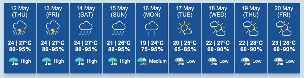
“A surge of the northeast monsoon is expected to reach the coast of Guangdong on Sunday,” the observatory said.
“It will be windy with temperatures falling progressively over the region.”
Temperatures will fall slightly to 20 degrees or below early next week, it added.
With the trough of low pressure departing the coastal areas, the weather will improve gradually early or in the middle of next week, said the observatory.
With the monsoon moderating, temperatures over the coast of Guangdong will rise in the latter part of next week, it added.

